THE SOCIALIST REPUBLIC OF VIET NAM
Government News
Viet Nam braces for tropical cyclone Wipha
VGP - Tropical Storm Wipha, which formed early on July 18, is forecast to enter the East Sea on Saturday (July 19), bringing widespread heavy to very heavy rainfall to northern and north-central provinces of Viet Nam, including Thanh Hoa and Nghe An, early next week, according to the National Center for Hydro-Meteorological Forecasting.
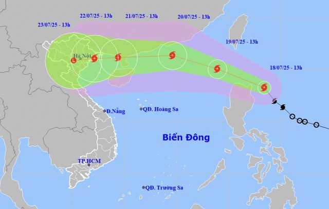
Projected path of Storm Wipha as it approaches the East Sea.
The tropical depression, which developed east of the Philippines, intensified into a storm early Thursday and was assigned the international name Wipha.
By 1:00 a.m. on July 19, Wipha is expected to move northwest at a speed of 20 km/h and gradually strengthen. Its center will likely be located over the northern waters of Luzon, with maximum sustained winds reaching level 8–9 and gusts up to level 11.
On Saturday afternoon, the northeastern part of the East Sea is forecast to experience strong winds of level 6–7, gusting to level 9. Wave heights may reach 2.5 to 3.5 meters, resulting in rough sea conditions. Maritime vessels operating in the area are advised to take extreme caution due to the high risk of strong winds, large waves, waterspouts, and severe thunderstorms.
From the night of July 19 into July 20, scattered showers and thunderstorms are expected across northern Viet Nam, with some areas experiencing heavy rainfall. A prolonged heavy rain event is forecast from July 20 to 25, with the northern region likely to be most affected.
Authorities continue to closely monitor the development of Storm Wipha. The National Center for Hydro-Meteorological Forecasting will provide timely updates to aid emergency preparedness and response efforts nationwide./.