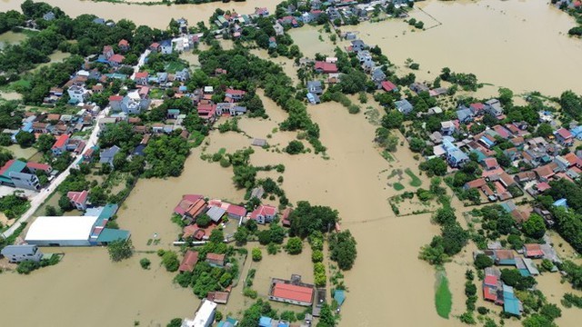
Northern Viet Nam experiences unprecedented consequences of typhoon Yagi
VGP – Massive flooding and landslides triggered by typhoon Yagi have caused devastating consequences in Northern Viet Nam over the past days.

Several localities in the Red River Delta are to face inundation over the next days as flood water levels in Northern mountainous provinces remain high
While mountainous provinces such as Lao Cai, Yen Bai, Hoa Binh reported deadly landslides, leaving at least 120 people dead and missing, many parts of other low-lying localities in the Red River Delta like Ha Noi, Bac Giang, Bac Ninh, Thai Nguyen, Ninh Binh, Nam Dinh, Thai Binh, Ha Nam, and Hai Duong are still facing severe inundation due to high flood water levels in northern rivers.
Flood water level in Cau River in Bac Ninh province reached 7.79m on Thursday night, or 1.49m above the Alert level 3, and just 5cm compare to the record water level in 1971. It is forecast that the Cau River's water level will recede slowly but remains above the Alert level 3.
Flood water level in Hoang Long River in Ninh Binh province rose to 4.88m, or 0.88m above the Alert level 3 as of 1 a.m this morning. The water level recedes slowly and remains above the Alert level 3.
Flood water levels in Thuong River and Luc Nam River in Bac Giang province reached 7.06m and 6.32m, respectively, all above the Alert level 3.
Flood water level in Red River in Ha Noi reached 10.05m, or 45cm below the Alert level 2 and is expected to gradually decrease to below the Alert level 1.
This is the first time flood water in Ha Noi rose to record high in 20 years while flood water level in Thao River's surpassed the record level in 1968.
Given the above situation, inundation will continue over the next days in Ha Noi, Bac Giang, Bac Ninh, Thai Nguyen, Ninh Binh, Nam Dinh, Thai Binh, Ha Nam, and Hai Duong, according to the National Center for Hydro-meteorological Forecasting.
High flood water levels may pose risks of landslides and collapses of dykes in Ha Noi, Ha Nam, Nam Dinh, Hai Duong, Thai Binh, Hung Yen, and Ninh Binh.
The National Center for Hydro-meteorological Forecasting said heavy rain is anticipated in several northern localities on Friday evening.
Regarding human losses, at least 330 people have been killed and missing in Viet Nam in the aftermath of the typhoon, the strongest storm in the East Sea over the last three decades.
Around 6.1 million customers experienced power outage due to the impacts of the storm.
At least 140,000 houses were damaged and 130,000 people had to evacuate to safe places./.

