THE SOCIALIST REPUBLIC OF VIET NAM
Government News
Viet Nam braces for Super Typhoon RAI
VGP – Super Typhoon RAI is expected to weaken before entering the East Sea, however, it remains a powerful and rare tropical storm that may hit Viet Nam, according to the National Center for Hydro-meteorological Forecasting (NCHMF).
|
|
|
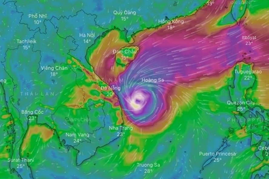
Super Typhoon RAI is forecast to enter the East Sea |
Deputy Prime Minister Le Van Thanh signed Public Telegram 1737/CD-TTg on urgent responses to Super Typhoon RAI.
The typhoon has directly affected coastal areas in the East of the Philippines with maximum wind of level 16, and a gale of level 17.
The NCHMF reported this is a very strong, fast-moving storm, occurring at the end of the stormy season, with very complicated developments.
The Government tasked the Central Steering Committee for Natural Disaster Prevention and Control, relevant ministries and localities to keep a close watch on the storm.
Specifically, the People’s Committees of coastal provinces and cities were requested to call upon vessels (including fishing and transport vessels and other vehicles) to seek shelters.
The Ministry of Health was tasked to ensure preventive measures during pandemic time especially at evacuation sites.
Mr. Tran Quang Nang, Head of the Weather Forecast Department under NCHM was quoted as saying that over the past 50 years, eight super typhoons (over level 16) have appeared in the northwest of the Pacific Region. In 2016, there was a super typhoon which was measured at level 16 when it slammed the the Philippines. Then, it weakened to level 10-11 in the East Sea of Viet Nam. Hence RAI is a rare super typhoon. However, he warned that in the context of climate change, unexpected natural disasters may appear with more frequent rates, requiring more attention.
Earlier, Super Typhoon Rai, slammed into the eastern coast of the Philippines on Thursday afternoon, bringing torrential rain and the threat of widespread flooding across the archipelago.
The International Federation of Red Cross and Red Crescent Societies (IFRC) called Rai "one of the most powerful storms to menace the Philippines in recent years" that threatened "to hit coastal communities like a freight train”./.
By Khanh Phuong