THE SOCIALIST REPUBLIC OF VIET NAM
Government News
Ca Mau Brilliance in Southernmost Viet Nam
VGP – Ca Mau is the southernmost province in the country. It is endowed by nature with an abundant source of seafood, vast green forests of cajeputs and mangrove trees, large rivers and pristine beautiful natural scenery. These are the resources that benefit the economic and tourist development of the province.
Ca Mau City is one of the four major areas of Mekong Delta's economic zone
Exploring Ca Mau province
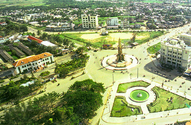
From Ca Mau City, we started our journey to discover the southernmost land of the country. Situated in the centre of the city is the imposing Victory Monument which demonstrates the typical strength of the land and people of Ca Mau. We went through calm streets with simple and peaceful houses lying through calm streets with simple and peaceful houses lying near the banks of the river and visited boat-building workshops and busy markets where many typical specialties of the sea and orchard gardens were sold.
Talking about Ca Mau is to refer to a pristine natural land with immense forests of mangrove and cajuput trees, vast rivers and canals and specific cultural characteristics that no other places have.
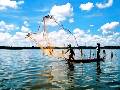
Ca Mau has eight rivers that run through the province, forming large estuaries with over 7,000km of rivers and canals, creating the unique beauty of a watery area and diverse culinary specialties. This is a treasure that brings advantages to Ca Mau to develop a tourism industry with specific characteristics.
From Ca Mau City we went towards the western coast and soon reached the Lower U Minh National Park. We climbed to Vong Lam Dai where looking down we saw green mangrove forests in the four directions. The Lower U Minh National Park is considered as a “green lung” of the southewest. It is also the habitation of many species of birds, animals and aquatic creatures. The most attractive thing to visitors to this area is to eat grilled snakehead and follow the local people to go into the mangrove forests to prepare the places for the honey bees to make their nests.
In Tran Van Thoi District, which is not far from the Lower U Minh National Park, there is the Hon Da Bac Tourist Site which is about 180 million years old. This beautiful site looks like a water-color painting with high mountains mingling with the sea and sky.
We followed the path winding through the rice fields and reached Song Doc Town where boats carrying fish and shrimp are coming in and out throughout the day. Coming to Song Doc, visitors can not only contemplate the vast sea but also learn about the unique cultural feature of the local people, most typically the Lang Ong Nam Hai Festival, a traditional festival of the southernmost coastal residents.
The most interesting and significant is the tour to Cape Ca Mau, the southernmost point of the country, in Mui Hamlet, Dat Mui Commune, Ngoc Hien District. Dat Maui is over 50km away from Nam Can Town and it took us more than an hour to go from the town to Dat Mui by motorboat. It was a very interesting trip because we enjoyed the feeling of surfing by motorboat on a vast sea and through the vast mangrove forests in the cool sea breeze.
Cape Ca Mau with the national landmark and its icon of a ship facing the sea gradually appeared. Cape Ca Mau is the only place on the country’s mainland that sees the sun rising from the East Sea and settling in the western sea.
In the west of the cape there is an alluvial area where the Mam trees (Avicennia) grow and spread, followed by the growth of the mangrove trees with fasciculate roots, making the area expand dozens of meters a year to the sea. While our motorboat was running through the mangrove forests we saw the upright mangrove trees with large roots firmly striking into the ground. We visited the simple houses without door of the fishermen and enjoyed the specialties, such as grilled mudskippers, grilled oysters, shrimp and crabs. We had an unforgettable feeling when we visited this beloved area.
In Ngoc Hien District there are other interesting tourist destinations, such as the Hon Khoai Island, Vam Lung Wharf and the milestone No. 0 on the legendary Ho Chi Minh sea route. In the near future, when the Nam Can Bridge is inaugurated linking Ngoc Hien to the mainland, this area will have opportunities for further socio-economic and tourist development.
The Cape Ca Mau tour has contributed to the development of tourism in Ca Mau. In 2013, Ca Mau received over 800,000 tourists, including over 18,000 foreigners. To better exploit the available tourist potential, Ca Mau should create more tourist products, connect the tourist routes, strengthen the promotion measures and build comfortable accommodation facilities in the main destinations.
 |
Advancing with a “Three-legged” position
The natural conditions provide Ca Mau with special advantages for economic development with a strong “three-legged” position which consists of three strong main pillars: fishery – agriculture – forestry (37.1%), industry (36.9%) and trade – services (26%).
The first and also the strongest “leg” in the economic structure of Ca Mau is the fishery – agriculture – forestry, in which the fishery sector accounts for 30% of the provincial GDP. Ca Mau Province has the most developed fishery in the Cuu Long River Delta and has the highest aquaculture area and output in the country. Bordered by the sea on three sides on three sides, Ca Mau has a coastline of 254km, the fishing ground covering over 70.000km2 and large saline wetlands, favorable for aquaculture. In 2013, the total output of aquatic products in the province was estimated at 440,000 tons; the aquaculture area was 296,000 hectares in which the shrimp farming area accounted for 90% with over 140,000 tons.
To strengthen the fishery sector, the province has invested in developing an offshore fishing fleet of nearly 5,000 boats and building fish wharfs and ports. The businesses in this sector has also focused on the renovation of technologies and equipping their facilities with modern machines.
Besides seafood, Ca Mau has over 130,000 hectare of rice cultivation area which yields more than 560,000 tons of paddy a year. In forestry, Ca Mau has a huge carpet of primeval cajuput forests in the Lower U Minh National Park and the world’s second largest mangrove forest, after the Amazon forest, in the coastal wetland of the Cape Ca Mau National Park. In May, 2009 UNESCO recognized the Cape Ca Mau National Park and Lower U Minh National Park as the World Biosphere Reserves. In April, 2013 the Cape Ca Mau National Park was recognized as the 2088th Ramsar site in the world.
|
|
|
The automatic packing system in Ca Mau Fertilizer Plant - Photo: VNP |
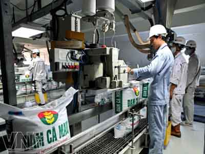
Ca Mau City, the capital of Ca Mau province is a brilliant point in the industrial picture of the province. It accounts for over 70% of the industrial production value of the province. In the city, there are many large groups and companies engaged in processing the aquatic products. So the stature of one of the four dynamic cities in the economic zone of the Cuu Long River Delta has been gradually confirmed with remarkable achievements in the socio-economic development.
The third “leg” is the trade – services. In this field this province has implemented many promotion measures to help the businesses expand the market and increase exports. Thanks to these efforts the export turnover of the province in 2013 reached over US$ 1,050 million. Aquatic products are the main exported products and have been exported to over 30 countries and territories, such as the United States, Japan and the EU.
With a spirit of efforts, from being a poor province, after 16 years of re-establishment, Ca Mau has become one of the four provinces in the key economic zone in the Cuu Long River Delta. In 2013, the provincial GDP reached over VND 19 trillion, an increase of more than 4.6 times compared to the time of the provincial re-establishment and the income per capital/year was about US$ 1,390, an increase of more than four times.
Talking about the future of the province, Pham Thanh Tuoi, Chairman of the People’s Committee of Ca Mau Province said that the province had built a master plan with a long-term vision, focusing on investing in the development of overall infrastructure, especially in the key projects. In the immediate future, the province would promote the exploitation of the sea economic, forest and tourism potentials./.
(Viet Nam Pictorial)